The story of Scotland’s new towns
by Katie Wishart
Background
As outlined in the ‘Marmite Housing: Glasgow’s public housing boom’ paper on this website, the early post war period saw Glasgow’s working population living in poor quality, unsafe and crowded housing conditions. Deprivation was rife and the scarcity of available housing was well below that of the growing population’s needs. It was widely felt there was an urgent need to rethink how Glasgow’s working population were to be housed. Surely a nation recovering from two wars in thirty years deserved adequate housing.
In 1946 the immediate civic solution to the housing problem was laid out in Sir Patrick Abercrombie’s Clyde Valley Regional Plan. The Plan was extensive and a number of proposals were made but the focus was essentially twofold: (i) to build housing estates in the City’s peripheral areas, and (ii) identify specific sites (e.g. Cumbernauld, East Kilbride) where satellite New Towns were to be built. The Plan proposed to reduce Glasgow’s population by 250,000 people (approximately 25% of the total) and allow both inner city construction and development of peripheral estates for those who remained.
This paper will explore the New Towns that were built to house the so called 'Glasgow overspill’. It will cover the origins and development of four key Scottish New Towns with a focus on town layout and housing design and identify some notable successes for each.
New Town Origins
The post war period saw a burst of enthusiasm for the development of satellite towns to solve the problem of overly populated and chronically under housed cities within the UK.
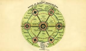
A key precedent was the Garden City Movement, an early 20th century urban planning movement promoting satellite communities surrounding the central city and separated with greenbelts. These Garden Cities contained proportionate areas of residences, industry, and agriculture had been prominent from the beginning of the 20th Century, including Letchworth and Welwyn Garden City which were built near London according to the concept. Scotland was not without its own experiments in this mould, prime examples being Robert Owen’s self-contained community New Lanark on the banks of the Clyde founded at the turn of the 19th century and Rosyth which was founded in 1916 alongside the Rosyth Dockyard naval base.
The development of these Garden City’s underlined the possibility of housing overspill population in satellite towns and the building of New Towns on a similar basis was felt to be a viable option.
This enthusiasm became reality in 1948 with the introduction of the New Towns Act 1946 which laid the legal basis for the building New Towns at scale in the UK. The Act provided powers for unelected public sector bodies called Development Corporations to be established whose role was to coordinate the building of designated New Towns in greenbelt areas.
The focus of the New Towns would be not just to ‘solve’ in part the overspill problem but also to encourage new industry. The intention was to create self-contained communities with schools and shopping alongside other amenities with residents working in local industries, and to also invent new patterns of urban development and architecture.
The first UK new town designated was Stevenage in England in November 1946, quickly followed by Crawley and Hemel Hempstead in early 1947.
New Towns in Scotland
Using the powers in the 1946 Act, the Scottish Office proceeded to designate six New Towns in Scotland between 1947 and 1973.
These were -
- East Kilbride (designated 6 May 1947)
- Glenrothes (designated 30 June 1948)
- Cumbernauld (designated 9 December 1955)
- Livingston (designated 16 April 1962)
- Irvine (designated 9 November 1966)
- Stonehouse (designated 17 July 1973).
Planning and construction of each of the New Towns were overseen by the Scottish Office and Development Corporations were set up, primarily financed by the UK Government through Treasury loans as enabled by the 1946 Act. The Scottish Office aspired to adopt a considered approach to housing and industry with improved standard of design and architecture at the forefront. The impetus was a move towards positive mainstream modern designs in order to attract modern Scottish people and build a modern forward-looking Scotland.
As Glenrothes was primarily built to provide housing and a community for the workers of the new Rothes Colliery and Stonehouse was de-designated in 1976 after fewer than 100 houses had been built, this paper will limit itself to an overview of East Kilbride, Cumbernauld, Livingston and Irvine as these were specifically built to accommodate Glasgow’s overspill population.
East Kilbride
East Kilbride has the honour of being Scotland’s first New Town with work beginning in 1947, soon after the introduction of the 1946 Act. The East Kilbride Development Corporation (EKDC) was established in 1947 with personnel expertise and experience from a variety of areas. For example, the Chairman was Sir Patrick Dollan (former Lord provost of Glasgow); General Manager was Major-General Dixon (retired Royal Engineer); Chief Architect was Donald Reay formerly Chief Architect of Glasgow City Housing Department. The Secretary of State for Scotland Joseph Westwood attended the first meeting of the EKDC Board in August 1947 underlining its political importance at that time.
The ambitions for the New Town were set out clearly. The designated area was 10,254 acres, 21 kilometres southeast of Glasgow with 40% of the area intended as Green Belt. An existing village with a population of around 2,500 in 1947 was to be expanded with the target population set at 45,000, reached within 10 years, which was a major achievement.
Town Layout and Design
The design approach was to build a low density and dispersed neighbourhood-based plan with much in common with so-called Mark 1 towns in England, e.g. Basildon. Mark 1 towns were characterised as being self-contained and balanced communities (i.e. a comprehensive mix of housing, employment, and facilities within the town's boundaries); clear, simple layouts (i.e. residential areas grouped into "neighbourhoods" arranged around local centres, with a major town centre at the core); separation of functions (i.e. functional separation of residential areas from industrial estates by a buffer of green spaces); pedestrian-friendly core (i.e. use of pedestrianised town centres to minimise conflict with traffic, with radial roads a common feature to improve transport links).
The initial layout put forward for East Kilbride in late 1946 was organised around distinct neighbourhood units. The target population of 40,000 was to be divided between four identifiable areas of 10,000 to 15,0000 people, each enveloping a town centre and each neighbourhood therein was to be divided into two subunits.
The neighbourhoods were divided by the town’s major roads with each having their own school provision (i.e. one non-denominational secondary school, two primary schools and provision for Roman Catholic education), local shops, network footpaths, community facilities and cycleways with links to the town centre. The neighbourhoods were to encircle the town centre which had an Americanised indoor mall as its focal point, with dual carriageways and ample parking outside signaling the age of the car for the modern town dweller. Each neighbourhood had a local centre as part of the hierarchy of shopping and service opportunities, pedestrian squares were created with shops located under residential flats and the whole forming sheltered quarters with landscape, sculptures, pubs and bus stops.
The areas were to be accessed safely for pedestrians via paths and underpasses separate from main roads (e.g. Calderwood, Greenhills, The Murray, St Leonards and Westwood which were all the original areas when the town was built) and industrial estates were concentrated in the outskirts in northern, western and south-eastern directions (i.e. Nerston, College Milton and Kelvin respectively).
Housing: Early Neighbourhoods
The early neighbourhood areas were The Murray, Calderwood, Westwood and East Mains with all four starting at the same time in the late 1940s and developing at the same pace over a lengthy period. These early neighbourhoods were largely comprised of houses rather than flats, laid out in urban terraced arrangements which departed from the semi-detached suburban and cottage style of housing in the inter war estates (e.g. Mosspark in Glasgow). A variety of household types presented a more visually varied townscape from an architectural point of view. Other designs were traditional with three-story blocks of bay-windowed flats bordering grid-pattern terraced houses. About two-thirds of the housing consisted of two-storey terraces with the remainder being flats mostly three- or four-storey high. The houses were primarily constructed by the Development Corporation itself, with about 5% built by private builders.
The Murray
A good example of this early neighbourhood housing can be found in the northern part of The Murray which sits directly south of the town centre and was the first area built. The area was conceived as an integrated whole with arrangement of feeder roads and small cul-de-sacs, mixture of houses, low-rise flats, shops and schools. Houses were arranged in terraces, staggered or set at angle suggestive of an urban sensibility providing enclosure and definition to the street without denying each house its own private outdoor space. A mix of modernist and more traditional styles were built to provide accommodation for workers needed at the local Rolls-Royce factory. The Murray was the first neighbourhood to be completed and included some flats above shops.

Westwood
The Westwood area was built in two stages. In the first stage, on the lower slopes of the north facing hill, rows of houses are step up at right angles to the slope starting on a platform above a long row of garages. The houses are conventionally arranged with open fronts including a large area of communal space, and private back gardens with roads running along the contours so that deliveries must be made on foot. A flurry of T-shaped blocks of four-storey flats are mixed in with the houses, generally along the access roads, and give a fairly high density of dwellings. Both the houses and flats share an impressive view across Glasgow to the mountains beyond, but the layout and the buildings are nevertheless conventional.
Just below the top of the hill housing is different in style and layout. Two continuous terraces are rung along the contours of the hill with pairs of individual, white-painted houses or flats being recessed or set forward. Parking is arranged in small groups and there is a footpath linking all the houses through a sequence of public spaces terminating in a small square. Many of the houses in the area have even better views over Glasgow than the houses on the lower scheme, achieved with a minimum of roads and a maximum of public and private open space. This creates an environment which provides sheltered open space against the bleak north winds whilst giving as many people as possible the advantage of the view to the north.
Later Neighbourhoods
East Kilbride expanded over the years, and the population target increased several times (e.g. by 1960 it was 70,000). By then a formal overspill agreement with Glasgow Corporation to decrease its housing list was in place and so there was a need to expand the neighbourhoods.
St Leonards
The development of St Leonards in 1963 was a product of this where the housing built were of a lower density, rents higher, and more owner occupier type housing built as ‘one off’ designs (e.g. Thorntonhall’s ‘executive housing’). A new emphasis on pedestrian and vehicle segregation was implemented with Radburn layouts favoured (i.e. house accessed from front via foot path while traffic routes and parking placed at rear). Most of the housing was two-storey houses with a Radburn system of footpath access (e.g. south of the neighbourhood centre around Glen Malic, Glen May and Glen Feshie Roads) which is the most common style of all in British New Towns.
Further innovations included house specifications updated (e.g. installation of central heating, timber cladding plus flat mono pitch roofs adding visual variety). Multi storey housing was also introduced with the first tower block ‘executive’ flats (with central heating, double glazing and coloured bathroom suites) built in 1967.
East Kilbride’s population was starting to age, so a group of houses for senior citizens were built located south-east of the neighbourhood centre on the opposite side to the Glen housing. Pairs of small, single-storey cottages are arranged around an open space, secluded but not cut off from the rest of the town.
Greenhills
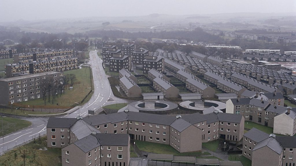
Greenhills was built after 1970 with its layout a revised precinct approach of earlier neighbourhoods though densities increased and full Radburn planning was abandoned in favour of a more intricate layout of courts and cul-de-sacs. The site was exposed by moorland winds and poor ground conditions with housing clustered into small groups sheltered by natural undulations with small gardens.
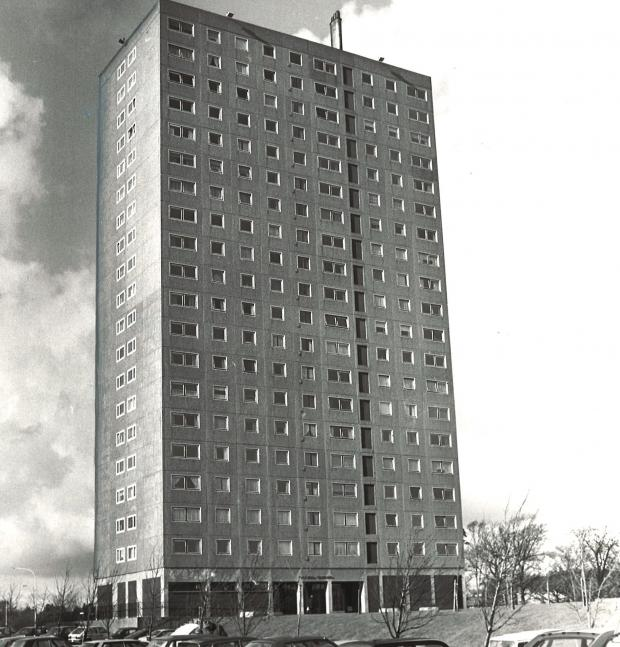
Clyde Tower, 1982
Other New Developments
Other new developments, such as Stewartfield, Lindsayfield, Gardenhall/Mossneuk and Jackson do not adhere as closely to this model and have a more generic suburban layout of low-density private housing, arranged mainly in cul-de-sacs fed by distributor roads.

Some Notable Achievements
The housing was not significantly different from the architecture, design and layout with that it was contemporary with and not intentionally innovative. The focus was to produce ordinary good quality homes which were not dissimilar to that of contemporary English New Towns, different only by use of render and roughcast and walk-up blocks of flats. Nevertheless, several showpiece buildings were also built by notable architects (e.g. Duncanrig High School by Basil Spence and St Brides Church by Gillespie, Kidd and Coia).
In 2011 an academic study “Long Term Experiences of Tenants in Social Housing in East Kilbride: an Oral History Study” noted high levels of aspiration were found amongst those who moved there including a strong desire to move on from overcrowded and blighted Glasgow tenement life. East Kilbride offered space, new homes (often with gardens and own front door), new facilities and a sense of community. The study recorded high levels of satisfaction with the quality of housing and the quality of life which became generational as children of first residents also set to make East Kilbride their home.
East Kilbride has also had a successful industrial history attracting many different companies, such as Rolls Royce, Motorola, Scottish Nuclear, and Fuji Electric. Historically, it was also home to the National Engineering Laboratory, which focused on flow measurement and testing, and early factories like Waterlow (printers of the Radio Times), Kurthers (pumps and cranes), and Lay porch (apparel). The area has been a base for other industries, including whisky production, bottling plants, and, more recently, the green energy sector, with the large Whitelee Windfarm located nearby.
Cumbenauld
Cumbernauld was designated as the site for a New Town on 9 December 1955 with an inaugural ceremony held on 28 June 1957 with Viscount Muirshiel Secretary of State for Scotland attending and the Cumbernauld Development Corporation (CDC) established under the 1946 Act. Unlike East Kilbride, Glasgow Corporation was to make a financial contribution to the development of £140 per house for those with nominated tenants for 10 years, an arrangement which lasted until 1972. The CDC Board included the prominent housing campaigner Glasgow Councillor Jean Roberts, which underlined Cumbernauld’s links with Glasgow’s redevelopment and overspill programme.
The area allocated was 10,254 acres lying between and incorporating the existing villages of Condorrat and Cumbernauld (population at that time 3,000) to house an original target population of 50,000 (revised to 70,000 in 1960). The area was compact and constrained in size in relation to the population target (three times the density of East Kilbride) and set on a hill between 260 and 480 feet above sea level with an exposed setting. These factors influenced the design of the designated site necessitating higher housing densities than older new town’s and which resulted in a more ’urbane’ development.
Town Layout and Design
The first Chief Architect and Planning Officer Hugh Wilson were satisfied there was a need for higher density solutions and built up a multi-disciplinary team drawn of planners, architects, landscape architects and engineers from UK and abroad working side by side. A number of multi-professional design groups were headed by Wilson fostering a spirit for innovation and risk taking. One of the major challenges for the Team was the topography of the site which required and resulted in mould breaking solutions,
The design of Cumbernauld started in 1955 and resulted directly from criticisms of the Mark 1 New Towns, including East Kilbride, as ‘prairie planning’ and the ‘product of garden-suburb sentimentalists’ which were characterised by wide picturesque curving line-treed roads and spaced-out neighbourhood units (i.e. low-density housing and industry). Instead of spreading out over large areas of countryside in ill-defined neighbourhoods, Cumbernauld was to be compactly clustered around the top of a hill, within a short walk of 10 minutes from a mid-20th century reinterpretation of the medieval town centre, with a single town centre on the hilltop (the so-called megastructure’). The design also recognised the importance of private motor car and effect it could have on the structure of the town. A‘whole-place approach’ was effected, consciously departing from the ‘neighbourhood’ principle adopted in the previous New Towns.
As a pioneer Mark 2 New Town, Cumbernauld was conceived with a broader economic and social vision than the earlier Mark 1 towns often criticised for their uniform and bland modern, concrete architecture. Mark 2 towns often featured more innovative and varied architectural styles and began to make more extensive provisions for cars, distinguishing them from the earlier generation.
The separation of people and cars was a major element of Cumbernauld’s first town masterplan, and this was carried through for much of the development of the town. The town is organised around a hierarchical road network which segregated foot and vehicular traffic and systematised cross-town movement, with priority given to pedestrian pathways allowing most direct point to point routines. Cumbernauld pioneered designs for underpasses and pedestrian footbridges as well as segregated footpaths. The residential structure of Cumbernauld was noteworthy in that there were no pedestrian crossings of any kind. Clusters of circular ‘bubble’ garages were built throughout the town including at Park and Abronhill.
In each area a local shop was built for every 300 houses usually comprising single story roughcast structures with deep black fascias, large pyramidal roofs and timber lining internally. A sense of continuity was retained by way of the naming of areas after farms that had previously occupied the areas.
Town Centre
The core of Cumbernauld is the town centre buildings, all of which are contained within one structure, often referred to as a ‘megastructure’. Acknowledged as the UK’s first shopping centre and the world’s first multi-level covered town centre, it was designed to be a commerce hub, entertainment and business venue and luxury accommodation site. As Cumbernauld never developed to its planned size the town centre has never achieved the lofty aspirations envisaged by its designers and has often been described as one of the ugliest and least loved examples of post-war design in Scotland. Nevertheless, a fascination with the megastructure remains as attested by the recent photography and essay book “Concrete Dreams: The Rise and Fall of Cumbernauld Town Centre” (Leslie, C et al) although it remains likely it will be demolished by North Lanarkshire Council in due course.
Housing
From the beginning housing design in Cumbernauld was ambitious and innovative. The earliest housing was designed principally by multi-disciplinary teams set up by Hugh Wilson with some undertaken by selected Scottish consultant architects. For example, Jack Coia (latterly RIBA gold medal winner) produced flats and houses in Kildrum virtually as the in-house team were assembled. East Kilbride had used the known and accepted palette of Scottish public housing, but Cumbernauld’s designers set out to develop both layout and house types from first principles.
The areas featured a continuous carpet of buildings low in overall height but deliberately more dense than Garden City modern patterns, i.e. instead of open and flowing space there are enclosed spaces. Although noticeably innovative in their approach, a foot was kept in older 1940s and 1950s pattern of mixed development and picturesque townscape planning by using tower blocks as vertical accents.
Some common characteristics of the housing were as follows - virtually all the housing streets were to be cul-de-sacs; houses were to have their public access side and their private side in which the main habitable rooms overlook the private garden or patio; garden fences were built high to offer privacy; considerable thought was given to topography and orientation of the houses regarding both where the sun shone in and resident’s view out; many houses overlook what was originally open countryside giving it a bucolic flavour.
The first new housing became available in 1958.
Early neighbourhoods
Early neighbourhoods were constructed at Ravenswood, Seafar and Kildrum, north of the town centre and Carbrain to the south. The town, bisected by a motorway, is a town of two halves; the southern half was built with modernist low-rise in a Radburn-style layout by the Development Corporation and the northern half was developed by the private sector, with the Development Corporation acting as a facilitator.
The housing was originally built in a series of satellite neighbourhoods clustered around the hilltop town centre with the original seven residential areas clustered into two zones. First, the northwest side looking towards the Campsie Fells where the Muirhead, Seafar and Ravenswood areas were built and, second, the southeast sloping away from the town centre comprised of Carbrain, Kildrum, Park and Greenfaulds. The four housing areas ring the centre, and each have two primary schools and two or three shops. Each area is separated from the other by a major road, impassable except for footbridges, and took on the characteristics of separate neighbourhoods.
The Northside and Southside housing zones were designed in contrasting ways. The Southside was deliberately compact and urban with a homogenous and overtly modern treatment including flat roofed housing dominating areas like Carbrain, with Kildrum’s ‘vernacular’ inspired terraces arranged in rows with outshoots. By contrast natural landscape was far more prominent in the steeper Northside (e.g. Seafar), which had a more abrupt and picturesque layout.
Park, Kildrum and Carbrain (Southside)
The architectural design and layout of the Southside area was highly varied, which the following illustrates.
Park 1: The first CDC Radburn development (built by Weir Housing as a higher rental manager’s development 1957-59) had a mixture of single storey timber clad houses, staircase access maisonettes and miniature point blocks with timber cladding also used for a group of adjacent private housing.
Kildrum 1: A housing project designed by the architectural company Gillespie, Kidd and Coia comprised of ninety-eight two storey terraced houses with flat roofs (completed 1958) and four and five storey blocs of maisonettes with garages below (completed 1961) all laid out in square courtyard layouts.
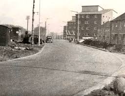
Kildrum Road, 1958
Carbrain: (1960) The northern part of Carbrain (1960) was built on a flattened site by contrast with Kildrum and the design was more overtly modernist with long flat roofed terraces. Southern Carbrain comprised of a high density ‘wall’ of houses with elevated walkways and were more steeply graded with multi-level or split-level housing types with gardens influenced by earlier Northside developments.
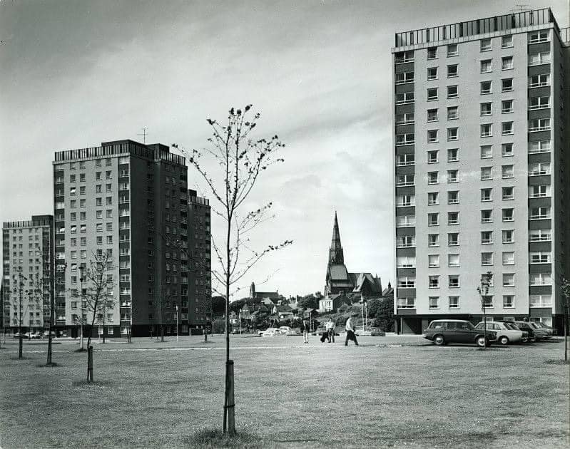
Burns Road : In the northeast of Kildrum two sixteen and one twenty storey tower clocks (Morison House, Elliot House and Stuart House) were built in 1969, all connected by walkways to a single large parking structure.
Kildrum also pioneered Cumbernauld’s idiosyncratic street numbering and naming system where each development at construction stage was known by area and section number (e.g. Kildrum 1) and much criticised for its complexity.
Muirhead, Ravenswood and Seafar (Northside)
Reflecting its far steeper topography facing directly across to the Kilsyth hills, the northside was given a more abrupt picturesque layout influenced by way of Gillespie et al’s input and by the modernist ideal of ‘Scandinavian forest’ landscaping.
A good example can be found in Seafar, which has an internationally recognised innovative layout and style of housing, sometimes mooted as one of the finest housing environments in New Towns anywhere and much copied. The scheme comprises of CDC built split-level houses on relatively steep north facing slopes and a range of small two-storey houses were assembled within a landscape of birch trees, heather and granite setts cast off from streets of Glasgow. The houses had ground-floor bedrooms and first-floor living rooms houses, which were in effect ‘flats’ set on the ground within a park.
Both Seafar 1 and 2 won Saltire Society Housing Design Awards on completion.

Cumbernauld Housing by the JR James Archive, licensed under CC BY-NC 2.0
Later Neighbourhoods
By 1961, only 5 years since becoming a New Town, the Scottish Office had increased Cumbernauld’s population target to 70,000 people and an additional 3,686 acres was added to the designated area to accommodate the new target. This led to rapid expansion with several later satellite areas added, (e.g. Cumbernauld village expanded into Abronhill (1964) from the northeast and late 1960s to southwest at Condorrat existing village). Low rise housing in Abronhill, Greenfaulds and Condorrat followed the already established pattern of earlier Cumbernauld housing.
A new extension zone to the northwest was designated in 1973, and developed in the 1980s-1990s, with the Balloch ward park north, Castlecary, Westfield and Blackwood areas setting a new trend for innovative high density private led housing developments. Good examples can be found in Westfield (built with densely landscaped communal courtyards off a public side to the grouped two-storey terraces, nearly covering them with natural growth) and Balloch (designers produced a winding village street centred upon a community shop, with parking courts accessed through arched vennels), both areas being commended in 1979 and 1981 respectively by the Saltire Society.
The 70,000-target population was never reached and the 2011 UK Census still showed there were about 52,000 residents at that time housed in more than a dozen residential areas.
Some Notable Achievements
Cumbernauld is regarded as representing a significant moment in town design, and in 1993 it was listed as one of the sixty key monuments of pos-war architecture by the international conservation organisation DoCoMoMo.
Indeed, in 1967 the Institute of American Architects voted Cumbernauld the world's best new town conferring the RS Reynold's Memorial Award for Community Architecture beating Vallingbay in Sweden and Tapiola in Finland. -“Scotland’s Cumbernauld is undoubtedly the most comprehensive project of community architecture to date. Rarely has a group of architects and their allied professionals and consultants produced a more carefully developed scheme on this scale. Throughout the project evidence is found of devotion to the overall problem and superb skill in urban design.”
Also, in 1967 CDC commissioned a household attitude survey from Strathclyde University’s Sociology Department who reported Cumbernauld as ‘a friendly town in which most of the people were satisfied … and 3/4 of residents considered they had bettered themselves by moving to the town.’
Nevertheless, by the turn of the millennium Cumbernauld fell out of fashion and was a two-time winner of the Carbuncle Awards in 2001 and 2005. Critics found the exposed concrete unappealing in the Scottish climate, and problems like water ingress and poor drainage led to later modifications (e.g. covering over open "streets"). It was also described in some contexts as "a rabbit warren on stilts" or the "Kabul of the North".
Cumbernauld has turned things around since and won a host of design awards -
- 'Best Town' at the Scottish Design Awards 2012.
- The Royal Town Planning Institute (RTPI) awarded the town a certificate in March 2014 for its success as a New Town.
- In 2015 the Town Centre was awarded the Green Apple Environmental Award.
- Cumbernauld won the 2013 Beautiful Scotland Award for the best "Small City". It has also received silver medals each year since 2009, the most recent being in 2017.
- In 2017 Cumbernauld was also awarded the Garden for Life Biodiversity Award.
Livingston
With the redevelopment of Glasgow predicted to be so advanced by 1965 as to require 1,000 houses per year more than could be accommodated in the existing three Scottish New Towns and ‘overspill areas’, another New Town was deemed an essential requirement. Livingston New Town was designated on 16 April 1962 with three villages (Livingston Village and Livingston Station in the old parish of Livingston and Bellsquarry in the parish of Mid Calder) and numerous farmsteads incorporated. The area covered 6692 acres, double that of Cumbernauld with the intended population target at 70,000 (80% intended to be Glasgow overspill) and lay 39 miles east of Glasgow.
In addition to absorbing Glasgow ‘overspill’, the New Town’s other key purpose was to provide a new focus for industrial activity in Scotland’s central belt and to link the industrial west with centres of expansion in the Forth basin, while revitalising a coal and shale mining area through modern industry.
Livingston Development Corporation (LDC)’s Board appointed Sir David Lowe, a local large-scale farmer and businessman, as chairman. The first Chief Architect and Planning officer was Peter Daniel who had professional qualifications in town planning, architecture and landscape architecture, and had experience of housing design in Peterlee New Town in County Durham.
There was a strong focus on attracting new industries compared to East Kilbride and Cumbernauld and more of a focus on owner occupation (e.g. by mid-1960s target of 25% owner occupation set for all new towns). Mooted as Scotland’s ‘Silicon Glen’ it was to be at forefront of bringing high-tech inward investment to the central belt.
Town Layout and Design
Published in July 1962, the first edition of the Livingston plan designated new areas for housing for up to 100,000 people, as well as areas for new industry and offices, marked by new roads, pathways, and recreational spaces, under an 84-square-mile survey led by Professors Donald Robertson and Sir Robert Mathews. The self-containment approach adopted by East Kilbride and Cumbernauld was abandoned for a broader approach which conceived Livingston at the centre of a large urban region of 80 square miles which would act as a single interconnected market for goods and services linked by railways and M8 motorway. The designated area sat in the valley of Almond with Livingston’s ‘town centre in the valley’ and was the antithesis of Cumbernauld’s ‘town centre on a hill’.
The design focus was on a so-called flexible grid system, i.e. an arrangement of main routes in grid form. The grid responded to a desire for flexibility, to provide a basic but adaptable framework for development formed but not too prescriptive. It was a pioneering attempt to develop an urban form which would offer maximum flexibility of design at each stage of development. The road pattern gave access to central urban functions at same time as connecting regional roads direct to industrial areas and principal industrial areas were located in the east and west of the designated areas.
Twelve housing districts and four industrial districts were distributed within the traffic grid and within each residential district there is a single peripheral ring road which serves the houses and most of the public buildings. A town designed for cars, cul-de-sac roads spur inwards from the district roads lead to car parks, garage and access paths to houses with one parking space per house.
The town’s landscape was a key element with a major aspect of the plan the ‘Greenways’, which are linear pedestrian links bringing the countryside into the heart of the town and linking to major areas of parkland and open space. A wayfinding system was set up with signage integrated into the gable ends of long ending terraces or on free standing concrete posts.
Livingston heralded a partial return to the initial intentions of New Town planners. Cumbernauld’s baffling roads and lopsided sprawl were banished in favour of grid-pattern streets and clearly defined low-rise districts surrounding a centre.
Housing
The original plan proposed 25% flats, but LDC provided an average of only 10-12% of dwellings in flats and mainly maisonettes of two and three storeys were built later extending to as far as five storeys. Residential construction began in 1962 with the first homes to be built as part of the New Town being constructed in Deans to house corporation employees and construction workers.
The houses were to remain low in overall height, configured in the form of a ’carpet’ as at Cumbernauld, with planned densities of up to 200 persons per acre around the centre, similar level to Cumbernauld at highest density. The actual gross density turned out to be only 59 persons per acre.
There was to be little spectacular architecture as Livingston was to restate the goal of modest excellence, key to East Kilbride’s success. Indeed, Livingston’s early ‘standard’ housing is offset by the high quality of its landscaping.
Early Neighbourhoods
The first major housing development took place in Craigshill in 1964, with the first people moving into the newly built housing areas in April 1966 at Broom Walk. The area comprised of three rectilinear rows of three- and four-storey flats and two-storey houses, designed by LDC architects and built by Laing in their Danish ‘12M Jesperson’ care concrete prefabricated system and infill timber, supplied from a newly built nearby factory. The architects had a new utopian vision of industrial built futurism and were initially lauded by councillors and architects internationally but the houses over time experienced irreversible damp and condensation problems. Known locally as the ’Piano Blocks’ because of their stepped sections, Craigshill South was part-demolished and part-refurbished in a postmodern style in 1987-9.
Elsewhere in Craigshill other approaches were adopted. For example, mono pitch roofs in the Courts area (LDC 1966), white terraces in the Groves area (1966), long terraces with colourful framed windows in Corston Park (1968, which won a Saltire prize) and interlinked semi-detached houses in Beauly Drive (1969).
Craigshill was said to embody a spartan, geometric approach to new town planning, with buildings composed of the Danish style Jesperson blocks and high-density, low-rise concrete homes with Scandinavian style mono-pitch roofs.
Later Neighbourhoods
The construction of the areas of Bowden, Ladywell, and Knightsbridge began in the late 1960s, and this was followed in the 1970s by the creation of Dedrige and further development of Deans. The peak years of construction were 1977 to 1981 and saw a return to traditional building methods, although the principle of low-rise, medium density housing arranged on cul-de-sacs with extensive pedestrian segregation largely remained.
This era links to ‘vernacular modernist’ movement in Scottish. The architectural focus was to align modern approaches with the single storey cottage rows historical Scottish style. As such terraced houses were prominent and featured vernacular details; for example, contrasting coloured hard and red brick brown, timber cladding, sloping steep or shallow slate roofs, projecting porches and irregular windows with contrasting-coloured surrounds. The houses were accessed by narrow paths on sloping dense sites with considered landscaping, with areas Ladywell and Dendridge illustrating the best of Livingston’s innovative housing layouts.
LDC architects incorporated these ‘old fashioned’ terrace plans and front facing gardens into more complex ‘neighbourhood’ housing layouts e.g. Bloom Court, Livingstone Village and Hanover Court, Kirkton and many terraced houses face onto parkland at Deans, Dedrudge and Craigshill.
The owner occupation target for Scottish New Towns was set at 25% in the mid-1960s and LDC started to design houses for sale from early 1960s most notably at Kirkton, Livingstone Village and Murieston. By 1990 private owners were 10% and by 1992 owner occupied resulted in 50% following the introduction of the right to buy option. LDC owned 90% of the town's housing in 1980 but, by 1996, this had been reduced to some 40% through sales and increasing private home ownership. This uptake in private ownership gave rise to the building of a different type of housing with Knightsbridge West Road, a good example ranging from bungalows with multiple bedrooms and bespoke hacienda style mansions.
Other Notable Buildings
Some of the first prominent buildings in the new town included Riverside Primary School (the first primary school built in the new town in April 1966), Livingston Fire Station (1967 by the architects Bamber & Hall), the new town's first public house (the Tower in Craigshill built in 1968), Craigshill school (the first secondary school built in the new town in 1969), and the 'Centre' (Livingston’s shopping centre) built in 1977.
There were no high-rise blocks, which is unique among Scottish new towns.
Some Notable Achievements
In a report published in 1997 by Dr Robert Rogerson and his team of geographers at Strathclyde University ‘Making Space for People’s Quality of Life” Livingston was rated second on a ranking of 189 best small cities and towns to live in the UK.
LDC received several Saltire Society Certificates of Commendation for housing and architectural projects in Livingston such as -
- Craigshill Housing (Certificate of Commendation)
- Howden Housing (Certificate of Commendation)
- Livingston Mill Farm (Commendation for the Regeneration of Scotland Design Award).
Livingston attracted major industrial corporations like NEC, Cadence Design Systems, and Digital Equipment Corporation during the peak of the "Silicon Glen" era in the 1990s. Mitsubishi Electric has been manufacturing air conditioning and heat pump systems in Livingston since 1994 and it recently relocated its UK Research and Development centre there with the aim of creating a centre of design excellence outside of Japan.
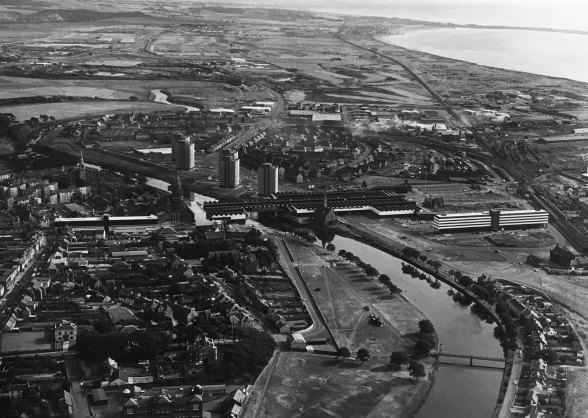
Irvine
In response to the 1966 Scottish Economy White Paper, which stressed the need for Scotland to attract more jobs in new industries and build more and better houses in good-quality environments, Irvine was designated as a New Town to provide a growth point for industrial expansion in Ayrshire. The fifth Scottish New Town, Irvine was different from its predecessors in that it was designed to meet housing demand arising from a rapid increase in labour and industrial development and the only one to be located on the coast. Its existing burghs of Irvine and Kilwinning had a population of 34,500 people at the time of the designation, a departure from earlier New Towns which were developed in largely rural sites.
The Irvine Development Corporation (IDC) was established in 1967 with the designated area covering 12,400 acres (including Irvine, Kilwinning and Dreghorn) and located 25 miles to south of Glasgow. The original target population was set at 116,000, which was reduced in 1981 to 95,000.
An initial plan was drawn up by the distinguished Wilson and Wormersley architectural practice (Hugh Wilson was the chief architect at Cumbernauld and Wormersley was famous for Park Hill scheme in Sheffield). IDC’s Chief Architect David Gosling gathered a young team of professionals and set out to emulate the example made by Wilson at Cumbernauld Development Corporation.
Town Layout and Design
The town is divided into residential districts, each with 4000 inhabitants, and within each district there is a school and corner shop. Several focus on a local centre with a large range of shops, a comprehensive school and health centre.
At the centre of each zone is a public transport route which links housing communities in a way which was not achieved in previous New Towns. Although it was expected that most people would have cars there was a recognition that those on lower incomes and higher density lower cost flats would need to be closer to public transport routes. As such, a system of ‘community routes’, mainly along existing roads and lanes were created providing short direct links between the residential units and other facilities. A network of leisure routes along areas of park land intended for walking were also created with the parks forming a linked system dividing residential areas and separating them from industry and other uses.
The Chief Architect’s team consciously avoided the Radburn system where cars strictly separated from pedestrians, most notably used in Cumbernauld, with individual garages attached to homes to minimise street parking.
Housing
From 1969 IDC aimed to build as many as 2000 houses a year split between the District Council, Scottish Single Housing Association, private enterprise and Local Authorities.
The proposed buildings were inspired by architecture of the Scottish high street with bright colour washes used along routes, while lower density housing behind would be increasingly monochromatic reflecting the vernacular arch of the farmhouses. There was an ambition to reflect traditional and vernacular Scottish architectural styles’ theme that runs through Irvine’s design history, complementing the modernity of the town centre. IDC also sought to emulate Cumbernauld’s early so called ‘abstracted vernacular’ style of housing, with using bold colours dual pitched roofs, stone margins to windows, extensive use of render and use of small-scale courtyard design.
Early Neighbourhoods
Pennyburn
Irvine’s first development was Pennyburn, completed in December 1969. The layout is a conventional New Town neighbourhood, with a ring road which feeds short access roads to the back of the houses. The main entrances are from one of the networks of footpaths which run all over the site independently of the roads. The scheme involved 8 landscaped squares with parking at entrances, each surrounded by 30 houses with courtyards introduced to induce neighbourliness following a traditional street front layout. There is a small shopping centre near the middle of the area alongside the only flats to be built here, and nearby the local first school is integrated into the housing with its playing fields providing the major public open space. The colour schemes used were white rendered contrast with dark stained timber and mono-pitch roofs and the area is a good example of typical housing of the late sixties. Such was the ambition to build good housing in the area, IDC’s Chief Architect David Gosling moved to Pennyburn for a period of two years to see for himself how his architectural ideas worked in practice.
Bourtreehill and Broomlands
Bourtreehill and Broomlands neighbourhoods were built in 1971. The area is divided into five residential units varying in size, defined either by grid roads, community routes or open spaces. Comprehensive schools, shops, health facilities, churches, pubs and other community buildings are placed at the centre of a population of about 10,000.
Although there is vehicular access to the residential unit from Towerland Road, the main circulation system is intended to be the community bus routes which are within a few minutes’ walk of all the houses and go directly to local centres and elsewhere in the town. There is also a combined footpath/cycle way system which runs at the back of most of the terraces of houses and is kept separate from the roads with underpasses. These pathways link to the 'leisure routes' which go through the linear park in the valley of the river Annick.
The two areas are situated around Broomlands Busway community route and share a local centre. The western part of Broomlands is arranged around a loop road, with two connections on the south side of Towerlands Road and inside the loop all the roads lead to a small group of local shops distinctively identified by dark terracotta paint. The shops are placed below three floors of flats with the height of the buildings contrasting with the surrounding houses which are occasionally two or three-storeys high. The community bus route runs past the shops and along the whole length of Broomlands before turning north towards Bourtreehill local.
The housing consists of three long rows of parallel terraces which open at the back on to the principal footpaths through the area and between these there are cross streets serving shorter blocks. All the houses are built with concrete blocks or mass concrete walls rendered on the outside and all the houses have pitched roofs, occasionally turned at right angles to give an interesting skyline. Terraces are broken up by protrusions and are given life by the use of strong colour either on window surrounds or over the whole wall surface. The footpaths which widen at times and double up as play spaces for young children continue towards the local centre in Bourtreehill.
Bourtreehill is located to the south of Towerland Road and divided into three parts bisected by the community route. The local centre located on the community route in the middle of Bourtreehill consists of a group of fifteen shops, a district library and a cafe, with either flats or offices above. Alongside the shops there is a church, a pub, an old people’s home and a health centre. Across the bus route old farm buildings have been converted into a community centre.
In Bourtreehill South, the arrangement and appearance of the houses is similar to Broomlands with long, almost continuous terraces. Bourtreehill North terraces have a much shorter and compact layout with small groups of houses arranged off parking courts with some houses facing the courts and others the footpaths. In some places the ground slopes steeply and existing fully grown trees have been preserved, both these features have been used to create a more varied layout. Notably Bourtreehill features an occasional dramatic black house, varied roof shapes and angles which provide interest to skyline of both areas.
The core design principles were consistent for both areas with topographical features providing an individual sense of identity. A criticism of the layout however is the length of the access roads where dead ends are long as many of those in Bourtreehill, particularly in the north where one is almost 1 km long. These dead ends prevent through-traffic and stop drivers taking short cuts through housing.
Later Neighbourhoods
Following a period of economic decline in the 1970s the population target was reduced to 95,000 in 1981 and then 63,000 in the 1990s which prompted a different approach. In 1983 IDC moved away from large scale developments towards a focus on merging together the existing town through renewal and restoration with small areas allocated for more experimental housing.
Architect Roan Rutherford spearheaded this new approach with one of his early projects including the well-received housing at Braehead (1978) featuring double-height living areas and pine-clad mezzanines. Further, his Heathfield House (1983) illustrated the importance of housing an aging population and won a 1983 Cici Trust award. The scheme provided twenty-one corridor-linked cottages in single storey ranges set around a courtyard connected to a communal space in a restored listed budding.
By the early 1990s IDC was again focused on constructing general needs housing. For example, Lawthorn in 1991 was planned with 1.5 storey houses laid out in staggered terraces arranged to take advantage of a sloping site, finished with small windows for privacy and larger windows to rear gardens plus generous eaves to shield buildings.
Restrictions on construction of housing were eased in 1993, and the Harbourside Masterplan of that year proposed a combination of restoration and new building. New buildings on the Harbourside (1995) at Peter St, Goitres Crescent and Cochrane St (all 1996) intended to have an urban quality. They were visually a mix of different influences including Arts and Crafts, Amsterdam School of early 20th Centre, vernacular with hauled walls and sculptural curved and angled bay windows. The cream-rendered buildings were essentially modern with a nautical demeanour, and sat alongside ‘heritage’ housing.
The last decade of the IDC’s life was characterised by the building of innovative and attractive housing. The hallmark details of plain white render, exposed rafter ends, ornate wrought-iron gable infills seen in different parts of town (notably Lawthorn) was a major departure in layout and architecture from 1970s areas (e.g. Bourtreehill which was drawn from common vernacular of Scottish New Towns thus far).
Some Notable Achievements
Commendations for Irvine’s housing developments were notable over the period 1984 and 1996 when IDC received 46 awards and commendations, 37 of which were for projects overseen by Roan Rutherford. For example, the Red Cross house 1987-92, whose purpose was to enable extended hospital stayers to reintegrate into community and provide services to disabled adults and young persons, won 7 awards.
The Magnum Leisure Centre was originally intended to be partly a superstructure running all the way from Irvine Beach Park into the town centre but only the leisure centre building and the central shopping centre were constructed. The Magnum was demolished in 2017 but is fondly remembered, indeed hosting many famous musical artists including Thin Lizzy, The Smiths and The Clash. Irvine Beach Park was also the setting for the Irvine Beach Festival in 1996 with top acts such as Bjork, Underworld and Supergrass headlining.
The Harbourside area has been transformed from a declining industrial area into a creative quarter with the following buildings of note:
- Scottish Maritime Museum: The main site of the museum was established in a former shipyard building on the Harbourside and has numerous vessels on display, including the “Spartan”, one of the last surviving Clyde puffers.
- Harbour Arts Centre: The former mission hall has been an arts centre since 1966 and is a significant cultural venue in North Ayrshire, featuring exhibition areas, a theatre, and spaces for classes and events.
- WASPS (Workshop and Artists Studio Provision Scotland) Artists' Studios: studios established to provide space for artists in the area to help turn the Harbourside area into a creative quarter.
- The Pilot House: The defunct tidal signaling tower is an important landmark of Irvine’s maritime history.
This work culminated in the Harbourside area being designated a conservation area in 2001, recognising its special architectural and historic interest.
Final Remarks
All the Development Corporations were wound up on 31 December 1996 following the dissolution of Strathclyde Regional Council. New single-tier Councils were established, and they took responsibility for the ownership and management of each of the Corporations’ housing stock (i.e. East Kilbride’s housing stock was taken on by South Lanarkshire Council, Cumbernauld’s by North Lanarkshire Council, Livingston’s by West Lothian Council and Irvine’s by North Ayrshire Council).
By 1996 approximately 50 years of New Town development in Scotland had taken place, a particularly intense period of pioneering experimentation in both town planning and architecture. Contrasting approaches to town design and layout occurred (e.g. East Kilbride’s low density, low rise standardised housing, car favoured town versus Cumbernauld’s high density, architecturally variegated and Radburn favoured town) but the central aim of building modern towns fit for the Scottish people was the unifying principle.
While it is true the New Towns have their detractors (one writer calling Cumbernauld ‘a heroic failure’) and there have been issues similar to those that have blighted Glasgow’s post war public housing schemes (e.g. design flaws such as flat roofs and prefabricated panels causing damp; lack of investment and maintenance caused by public funding cuts) the sheer scale, daring and ambition of the New Towns project must surely secure its legacy as a major civic achievement.
Bibliography
Abercrombie, Sir P. and Matthew, R. H., The Clyde Regional Valley Plan, 1946: A Report. Clyde Valley Regional Planning Advisory Committee Report to the Constituent Local Authorities,1947 (Edinburgh Stationery Office, 1949).
Abrams, L. and Fleming, L. (2011) Long Term Experiences of Tenants in Social Housing in East Kilbride: An Oral History Study. Project Report. School of Humanities, University of Glasgow. Available at: https://eprints.gla.ac.uk/58439/1/58439.pdf.
Abrams, L. et al, Building Modern Scotland: A Social and Architectural History of the New Towns, 1947 -1997 (Bloomsbury, 2025).
Bird, C. And Opher, P. Cumbernauld, Irvine, East Kilbride: An Illustrated Guide (Urban Design, Oxford Polytechnic, 1980).
Carbuncle Awards, Wikipedia. Available at: https://en.wikipedia.org/wiki/Carbuncle_Awards. (Accessed 26 November 2025).
Cowling, D., An Essay for Today: The Scottish New Towns 1947 to 1997 (The Rutland Press, 1997).
Cumbernauld, Wikipedia. Available at: https://en.wikipedia.org/wiki/Cumbernauld (Accessed 26 November 2025).
East Kilbride, Wikipedia. Available at: https://en.wikipedia.org/wiki/East_Kilbride (Accessed 26 November 2025).
Irvine Harbourside Heritage Website, Irvine Harbourside. Available at:
https://www.irvineharbourside.org/places_hac.php..
Irvine, North Ayrshire, Wikipedia. Available at:
https://en.wikipedia.org/wiki/Irvine,_North_Ayrshire (Accessed 26 November 2025).
Kalder, D., The heroic failure of Cumbernauld: the idealism of the New Towns became an ugly reality, Unherd Magazine website (2022). Available at: https://unherd.com/2022/03/the-heroic-failure-of-cumbernauld/.
Leslie, C. Et al, Concrete Dreams: The Rise and Fall of Cumbernauld Town Centre (Graphical House, 2024). Website: https://concretedreams.org.uk/.
Livingston, West Lothian, Wikipedia. Available at:
https://en.wikipedia.org/wiki/Livingston,_West_Lothian (Accessed 26 November 2025).
New Towns in the United Kingdom, Wikipedia. Available at:
https://en.wikipedia.org/wiki/New_towns_in_the_United_Kingdom
(Accessed 26 November 2025).
Rogerson R. (1997), ‘Making Space for People’s Quality of Life’. Report. University of Strathclyde. Available at: https://files.core.ac.uk/download/pdf/7051608.pdf.
Taylor J. (2010) ‘Cumbernauld: the conception, development and realisation of a post-war British New Town’. Thesis. Edinburgh College of Art. Available at: https://era.ed.ac.uk/handle/1842/8226.
Town and Country Planning Association, Factsheet on Cumbernauld. Available at:
https://www.tcpa.org.uk/new-town/cumbernauld/.
Town and Country Planning Association, Factsheet on Cumbernauld. Available at:
https://www.tcpa.org.uk/new-town/cumbernauld/.
Town and Country Planning Association, Factsheet on East Kilbride. Available at:
https://www.tcpa.org.uk/new-town/east-kilbride/.
Town and Country Planning Association, Factsheet on Irvine. Available at:
https://www.tcpa.org.uk/new-town/irvine/.
Town and Country Planning Association, Factsheet on Livingston. Available at: